BORMIO 360 ADVENTURE TRAIL

Host
Eden Hotel
Via Funivia, 3, Bormio
Details
This year our Valtellina is enriched with an additional novelty that aims to be a point of attraction for sportsmen and lovers of trekking and mountain biking: Bormio 360 Adventure Trail, the new outdoor adventure in Bormio.
It is a loop trail for outdoor enthusiasts that overlooks all of Bormio, from Valdidentro to Valfurva, from Valdisotto to Sondalo.
Let's find out about it in detail!
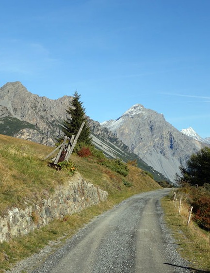
The Bormio 360 Adventure Trail is the first high-altitude route that completes a 360° loop around the Bormio area.
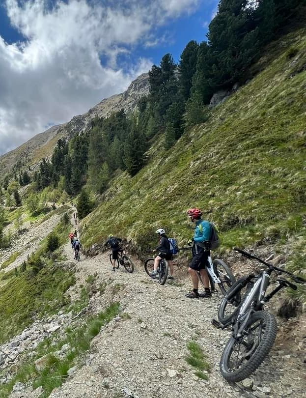
It is a long itinerary divided into 10 stages of different lengths, perfect to be done by MTB, e-mtb or on foot, one stage at a time, depending on your training and the type of walk you are looking for.
It will be an up and down on the slopes of the wildest valleys of the Stelvio National Park, between paved roads and dirt paths, in remote and rarely trodden places, you will always stay in the high mountains between 837 and 2462 meters high!
In short, much more than the usual panorama and beyond the best known routes!
The 10 stages of Bormio 360
Each of the 10 stages has its own particularity, length and elevation gain, but they are all united by the fact that they are set in a wonderful and unique context.
Let's look at them one by one to learn about their characteristics and peculiarities.
Stage 1: Water trail from Pravasivo to Torri di Fraele
Km: 11.8
Height difference in ascent: 811 m.
Difficulty: easy
Characteristics: the stage does not present any particular difficulty and crosses a landscape characterized by the roar of water in all its forms: the thermal waters already known in Roman times, the Adda River, the Cancano dams, hydroelectric pipelines and Scale Lake fed by underground springs.
Stage 2: Decauville Trail from Torri di Fraele to Arnoga.
Km: 12
Height difference in ascent: 43 m.
Difficulty: easy
Characteristics: from Torri di Fraele, you follow the scenic Decauville trail, named after the French inventor of a railway particularly suited to the uncomfortable mountainous areas that in the past was used to transport material for the construction of the hydroelectric plant and the artificial dams of Cancano, until you reach Arnoga.
Stage 3: Sentiero del Conte trail from Arnoga to Malga San Colombano
Km: 19
Height difference in ascent: 835 m.
Difficulty: medium
Characteristics: rather long stage suitable for people with a good workout. It crosses the Conte forest from which it takes its name, which is located in front of the village of San Carlo. In the past this forest, owned by a noble family, provided firewood and opera wood, as well as peat and coal.
Stage 4: Malghe Trail from Malga San Colombano to Alpe Zandilla.
Km: 17
Height difference in ascent: 953 m.
Difficulty: medium
Characteristics: a scenic stage characterized by the do background sound of cowbells. Starting point is Malga San Colombano, along the way you can stop at several points to admire the vast panorama over the Bormio basin and then continue to Malga di Cerdecc and Alpe Zandilla. An unmissable different viewpoint of the upper Valtellina!
(Please note: Due to problems with storm Vaia, work on the trail at Suena Campello has been delayed. Temporarily it is necessary to descend to Massaniga, climb back up to Monte along the ordinary road and reach Alpe Zandilla).
Stage 5: Mineral Trail from Alpe Zandilla to Palazzetto Sport Sondalo
Km: 18
Height difference in ascent: 509 m.
Difficulty: medium
Characteristics: the name of this stage comes from the discovery of finds of considerable mineralogical value.
Various types of minerals are still present on the trail, including quartz extracted in the industrial quarry that is still active today. In the first section you can admire the view of Valdisotto and Bormio, then the trail follows a military mule track. There are also clearly visible remains of trenches.
Stage 6: Sentiero de li Stria from Palazzetto Sport Sondalo to Fontanaccia
Km: 9.6
Height difference in ascent: 869 m.
Difficulty: medium
Characteristics: the itinerary retraces the steps of the inhabitants of the Alps who came up from the valley floor to tend the pastures. Even today, the path shrouded in 'alpine atmosphere, still retains a mysterious charm related to ancient legends of witchcraft and arcane events that occurred in these localities. It is said that, at the sound of the Ave Maria, a series of burning embers could be seen departing from the locality of Scala and heading for the nearby hamlets: these were the witches leaving the sabbath, retreating at the first light of dawn.
Stage 7: Rhododendron Trail from Fontanaccia to Malga dell'Alpe.
Km: 12.7
Elevation gain: 983 m.
Difficulty: medium
Characteristics: as the name implies, this trail is characterized by the presence of rhododendrons, an alpine plant ranging in color from pink-fuchsia to ruby red, which blooms up to 2400 m at the end of June. In particular, in the plain of S. Bernardo, where the charming little church stands, the bloom of the rhododendron offers the passerby a spectacular view.
The flowers are particularly sought after by bees, and since ancient times its prized honey has been produced; the leaves, on the other hand, are used for infusions, decoctions and compresses.
Stage 8: Ice Trail from Malga dell'Alpe to Forni
Km: 13
Height difference in ascent: 602 m.
Difficulty: medium
Characteristics: this is an interesting stage from a naturalistic point of view, plus it crosses the symbolic mountain of Valfurva: the Tresero. In these areas, the first forms of modern mountaineering were born as early as the 19th century: outsiders using local guides made the first daring ascents on the mountains and glaciers where even today there are refuges and bivouacs built above 3,000 meters above sea level.
Stage 9: Border Trail from Forni to Fantelle
Km: 21.9
Elevation gain: 529 m.
Difficulty: medium
Characteristics: a rather long but evocative stage, suspended above Valfurva, at the foot of Mount Confinale, among small nuclei of mountain huts and alpine pastures. Passing through centuries-old forests and rhododendron meadows, it is common to observe animal species symbolic of the Stelvio National Park such as bearded vultures, golden eagles, marmots and stoats.
Stage 10: Maghét Trail from Fantelle to Pravasivo
Km: 8.5
Elevation gain: 126 m.
Difficulty: easy
Characteristics: a fascinating stage from a cultural point of view. In fact, it is said that on the slopes of the Reit there roamed the "maghet," mischievous and malicious spirits who inhabited the mountains and who, if provoked, could cause damage and destruction.To protect themselves from their magic, the valley dwellers scattered the forests with votive chapels ("Santelle") and crosses, as if these had the power to thwart or ward them off. The tradition of the "maghet," is still told to children today.
The 10 stages are really all interesting, each with its own characteristics, but all united by the wonderful views of the entire Valtellina.
Have you already found the itinerary that strikes you the most? Or, try them all during your vacation in Bormio!
We are waiting for you to experience this summer 2022 novelty together!